
Dear reader, welcome to Estepona, I’m sure you are already thinking about having… a nice beer in the sun looking at the sea! Of course you can’t miss that, but now turn around and contemplate the incredible mountain that surrounds the back of the Esteponeros: Sierra Bermeja. It is a luxury to have a mountainous massif of almost 1500 meters high next to the seashore. Undoubtedly, this is what makes this Costa Rican municipality unique and special.
Before going into details, I want to clarify that the purpose of this article is not for you to learn about geology, fauna, flora and everything scientifically noteworthy about Sierra Bermeja, which is very diverse. What I want is that you fall in love with it and that when you finish reading this you feel an enormous desire to go up and meet it.
Sierra Bermeja, Natural Site, ZEC, ZEPA, ZEPA and RBIM
It is protected with the category of Natural Site since 1989, Special Conservation Area (ZEC), Special Protection Area for Birds (SPA) and is part of the Intercontinental Biosphere Reserve of the Mediterranean Spain-Morocco (RBIM) and that is because its geology and endemic flora is unique worldwide.

The only Spanish fir forest on peridotites in the world.
The first thing that will have caught your attention is its reddish color, which gives it the appearance of fire. The rock that forms it is of deep origin, coming from the Earth’s upper mantle. Sierra Bermeja is a colossal outcrop of peridotites that makes it a unique space in Europe and the Mediterranean, raising passions at international level.
The surprising thing is that this rock is green in color. Due to the minerals that compose it, when exposed to the exterior, the meteoric processes cause it to transform into that characteristic reddish color that gives its name to this mountain. Added to the contrast of the greenness of the pines and its flora make it a unique landscape that you can not miss.
The flora and vegetation of this natural environment is unique and growing on peridotite is not easy. The soils generated by this type of rock are infertile, very thermal, rich in heavy metals and magnesium, very rocky, lacking in calcium and nutrients and very xeric. Therefore, all the vegetation you are about to discover is exclusive, so take a good look at it and enjoy it.
Undoubtedly, the jewel of this mountainous massif is the Pinsapo, having the Esteponeros the privilege of having the only forest of pinsapos on peridotites that exists in the world.
How do I get to Sierra Bermeja?
The most recommended access is through the coast, accessing from the Avenida Los reales to continue along the provincial road MA-8301 (old MA-557) Estepona-Jubrique. It is a route of about 19 kilometers with many curves, so if you go with children take it into account. As we climb we will discover the masses of pine forests until we reach the Peñas Blancas pass, located at kilometer 15.1.
Get the right equipment to climb Sierra Bermeja
Don’t forget to wear warm clothes, especially if you go up in winter. On average in Sierra Bermeja, the temperature decreases about 0.5ºC for every 100 meters of elevation, so that in the summits of Los Reales it can be 6 degrees less and, on many occasions, up to 10 degrees less.
The effects of the Estepona fire in 2021
Before continuing, it should be clarified that the landscape of Sierra Bermeja has been damaged by the fire that occurred in September 2021, which ended with 9,581 hectares affected, 4,209 of which belonged to Estepona, and which leaves us with a memory of what should not happen again.

The cyclist’s viewpoint
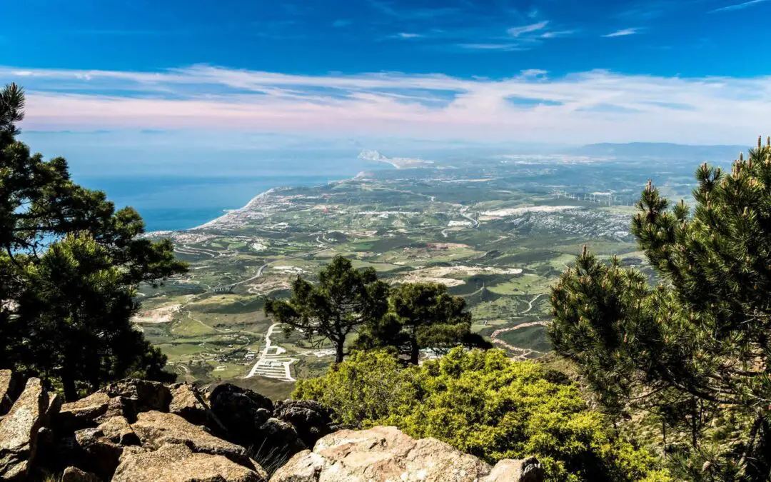
Your first stop will be at Km 9.9 at the Mirador del ciclista. Don’t think about it, get out of the car, and with luck if the wind blows from the west you will be able to see the Strait of Gibraltar in the background and above all another continent, Africa.
We will follow the mountain road surrounded by pines and Mediterranean scrub, strawberry trees and rockroses until we reach the Peñas Blancas pass. Here we will take a small road to the left that will lead us to the Pico de los Reales.
After the Peñas Blancas junction, we begin the ascent through a narrow mountain road to the top of Los reales, it is a journey of about 4.4 km and is a fairly narrow road that will make you sweat if you meet another vehicle in the opposite direction. Take it easy.
The first Spanish firs of Sierra Bermeja
During this route, the Pinsapos begin to appear and will accompany us until we reach the Agustín Lozano Mountain Refuge, where the Los Reales recreational area is located.
This area is equipped with tables and barbecues to spend a great day with family or friends. You can prepare a paella in the purest “Sunday” style or eat a restorative sandwich if you have done a hiking route. If you are one of those who prefer to have everything put in front of you, give yourself a tribute and make a reservation at Venta El Refugio, where you can taste the best products of the land served with love. Whichever option you choose, you can’t leave without having a good “Café de puchero”.

The shelter and the stars
This refuge retains its quality as a mountain refuge. Its front part is always open and has a fireplace in case the snow catches you off guard and you have to spend the night under the stars. You can also enjoy another of the wonders that our Sierra offers you and that is that, astrologically speaking, you have few places with such good access to install your telescope at 1,100 meters above sea level and away from all light pollution. It should be noted that the altitude and southern latitude of the peak of Los Reales de Sierra Bermeja make it possible to observe objects that are impossible to see from other sites on the European continent. If you visit us in August you can not miss “Las Perseidas”, I assure you it will be worth it.

Hiking trails?
Do not think that I have forgotten all the hiking trails that you can do in this natural enclave, but to discover them you will have to wait for the next post. Of course, before I say goodbye I recommend a little walk that will leave you wanting to discover much more. At the end of the road that has taken you to the Refuge and where you can park, known as Plazoleta Salvador Guerrero, begins a small trail of easy access and a length of about 500 meters that leads to the viewpoint that bears the same name. There you will enjoy panoramic views, especially if you choose a day with a westerly wind, where you will see the silhouette of the coast and the African continent.
You see, dear reader, Estepona is much more than just a beach!
