
Dear reader, today it’s time to take a walk and discover the wonders of our natural environment, because as I never tire of saying, Estepona is much more than a beach! Here is a selection of routes to enjoy with the family, suitable for everyone. The idea is to gradually introduce you to the art of loving nature, a fundamental step for the sustainability of our forests.
Of course, if you haven’t read the post about the Sierra Bermeja and its unique Spanish fir forest, I recommend you to take a look at it before starting with the routes.

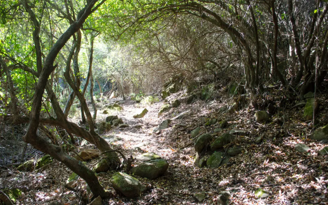
HIKING TRAILS THROUGH RIBERA FORESTS
We will start with three routes that have the same beginning and different variants. In them, we will enjoy the company of the Mediterranean forest with its rockroses, heathers, cork oaks, strawberry trees, carob trees and pines that will fill the path with scents along with lavender and rosemary.
The rivers of Estepona
All the routes we are going to describe below run between the Velerín and Castor rivers, so it is only fair to talk a little about the rivers of Estepona.
The rivers of Estepona, like all those that originate in Sierra Bermeja, are small isolated basins with unbeatable water quality, where extinct species of fish from other rivers survive and take refuge here in a relict-like fashion.
Like all Andalusian rivers that flow into the Mediterranean, due to the proximity of the mountains to the coast, they are short and not very fast-flowing. However, if it suddenly starts to rain, you would be surprised by the torrential rainfall due to the steep slopes of our mountain.
Their environmental importance is protected, in many cases, by the Natura 2000 Network as Special Areas of Conservation (SAC). They are protected ecosystems with the objective of contributing to ensure biodiversity through the conservation of natural habitats and wildlife.
From west to east, these are the most important rivers in Estepona, the last 5 being protected as Special Areas of Conservation (SAC).
- Vaquero Creek
- Arroyo Enmedio
- Río Monterroso
- Río Calancha- Calanchilla
- Río de la Cala
- Río Padrón
- Río Castor
- Río Velerín
- Río Guadalmansa
")
1- NICOLA’S ROAD – VELERIN
It is a circular route of about 6 km, of medium-low difficulty that runs along the right bank of the Velerín River. It values the characteristics of the rivers of Estepona, as well as its riparian forests.
It will start at the well-known Nicola road and through an easy dirt track we will start this route until we reach the Cortijo Nicola located on the left side of the road.
")
Nicola’s Cortijo
This construction is one of the most ethnologically interesting elements of the entire municipality. It was built in 1943 and has an added value due to its location, since it served as a link between different human settlements due to its proximity to the Igualeja Road, a real “highway” of communication with the Serranía de Ronda. This building stands out for its wine press, one of the largest in the municipality.
It is worth mentioning later constructions such as the pool or the bread oven, the latter of great magnitude, which suggests that it supplied a large number of people, both inhabitants of the farmhouse as well as neighbors and people passing through.
I do not recommend, dear reader, that you go inside it because its condition is quite deteriorated and because now it no longer serves as a refreshment area for hikers, but it has gained an unparalleled natural importance as it serves as a refuge and breeding area for species of bats, which are protected by law.
We follow the road until we find a livestock farm that will remind us that it is time to turn right and fall towards the Velerín River. You will know you are close to your destination by the change in the landscape: lemon and sweet orange trees appear, the Huertas del Velerín. Hopefully, if summer has not come too early, we will be able to soak our feet and enjoy looking for frogs and tadpoles, because we will have to cross it three times to reach the end of the route. Without a doubt, this will be the favorite part for the little ones!


2- NICOLA’S ROAD – CASA DE LOS GUARDAS
This route is a linear route of about 7.3 km of medium-low difficulty. The beginning of the route, as we have already indicated at the beginning of this post, is the same as that of the Nicola-Velerín route, also starting on the Camino de Nicola and ascending along the dirt track until reaching the livestock farm.
We will continue along the dirt road until we reach the place known as the Piedra de la Mentira, where we will follow the road turning to the right until we reach the Casa de los Guardas.
This construction of the first half of the last century is composed of two large aisles and lateral constructions. Everything is made of local stone (peridotites) and solid ceramic brick, with mud well enriched with lime as mortar. This building was the home of the carabineros, who guarded the area to prevent smuggling between the coast and the Serranía de Ronda.


3- NICOLA’S ROAD – BEAVER RIVER
Here is another linear route, a little longer, about 8.25 km of medium intensity. Of great environmental importance, since it ends in one of the most emblematic rivers of the municipality. In this route, as in the previous ones, the characteristics of the rivers of Estepona are highlighted, as well as its riverside forests. In addition, we have the added value of discovering during the route places of historical heritage of the municipality, as you have already been valuing in the previous ones.
This route shares the same path until we reach the area around the Piedra de la Mentira, where in this case we will take the path to the left to drop down to the Castor River.
From the Piedra de la Mentira we can observe the Nico Castle, another historical jewel of the municipality of Estepona:
At 340 m above sea level, we find the ruins of the Nico Castle. The first historical review of it is linked to the Hispano-Visigoth aristocracy that fixed its residence in the tower fleeing the Muslim pressure; where they would exercise, at first, activities of pillage and banditry. When the civil war (fitna) began during the rebellion of Omar ben Hafsun against the emir of Cordoba, an important population gathered in that place and the consequent construction of the castle was consolidated during the second half of the 9th century.
Bordered on the east by the Castor River and on the west by the Padrón River. And located 7 km from the coast. The kimberlite of its stones and the abundance of lime in the mortar have kept some of its walls upright throughout these centuries, despite the oblivion and plundering it has suffered in recent times.
But what makes this river special is its main inhabitant, the otter. Believe it or not, it is the one that gives its name to this river, since the people of Estepona used to call the otter as beaver, a northern rodent very similar to the otter and that lives in the same habitat.
We can not talk about the Castor River without talking about its geology, which forms different pools where you can enjoy a good swim on sunny days, or cool off if this route has heated you up. Without a doubt, the otter pond is a natural pool that you can’t miss!

HIKING TRAILS IN SIERRA BERMEJA
We continue our journey with four more proposals, ideal to get to know Sierra Bermeja in first person.
Sierra Bermeja is a unique place in Spain and in the entire western Mediterranean, as it is considered the best representation of serpentine ecosystems. These ecosystems are characterized by being very rich in heavy metals, especially nickel and chromium, which gives them very special characteristics and differentiates them from other types of ecosystems.
Sierra Bermeja has a very unique flora and fauna. We can find endemic and exclusive plants of this area, such as the silene of Sierra Bermeja or the pinsapo of the quarries, as well as a great diversity of animal species.
")
4- HORNO DE LOS ALMARGENES
Going up the road that takes us to the beautiful Natural Park of Sierra Bermeja, you will find a hidden treasure next to KM 12. This route is ideal to go with the youngest members of the family and introduce them to the world of hiking, which fills our lives with values. It is a linear route of 3 km round trip and of low difficulty.
This short trail will lead us, among pines, rockroses, heather and carob trees, to an old tar kiln. This oven is a testimony of the old forestry exploitation of our forests and of the disappeared trade of “peguero” in the pine forests of Sierra Bermeja.
From this oven, and through the resin of the pine trees, a highly prized product of the time was obtained, pitch, which was used for caulking ships, for medicinal purposes and for branding livestock. Pine resin has had an economic and cultural importance in Sierra Bermeja that has been lost today in almost all of Spain. The extraction of the resin from the pine trees (also called miera or turpentine) was done directly by making incisions in the trunks and then it was cooked or distilled using the pitch kiln. This forestry exploitation has had in Sierra Bermeja an economic and cultural importance lost today in almost all of Spain, although it still remains testimonially in some places.
The exploitation was carried out through the company LURE (Unión Resinera Española). At the beginning, the company carried out intense reforestation work in the mountains, although only using resin pine, which shaped the current landscape of Sierra Bermeja. According to the company’s archives, the Estepona factory was one of the most productive of the 25 factories that LURE had throughout Spain and which exploited 60% of the national resin.

5- FUENTE DEL PORREJÓN
After our first contact as family hikers, we have the next route very close, at Km 12.8 of the Peñas Blancas road. It is a linear route of about 5 km round trip that begins in a dirt road called Carril del Alacrán. You will be able to enjoy an incredible landscape of the beautiful Sierra Bermeja, with the green highlighting on its red rock, belonging to the mass of pine forests. Due to the fire that occurred in September 2021, our landscape is now sadder than usual, but you can take advantage of it so that the little ones can learn from the mistakes of the past, since they are the future.
We will reach the firebreak of the Loma del Nicio, which we must cross, and there we will turn off to the path on the right side, which will take us to the Fuente del Porrejón, located at the headwaters of the Castor River. You will see how the vegetation changes, entering an enclosed forest that will transport you to the fairy tales of elves and fairies for its enchanted forest aspect.
The Fuente de El Porrejón has existed for many years and relieved the thirst of lumberjacks, charcoal burners, muleteers, pegueros, etc. Originally it was simply a spring that sprang directly from the ground. The last remodeling carried out in May 2013 by the Ministry of Environment of the Andalusian Regional Government has given it its current appearance.
You may wonder when you get to the fountain, what is that little ramp inside it for? Well, it is a way to eliminate the verticality of its walls in order to avoid unnecessary drowning of the fauna that accidentally falls, facilitating the exit of the animals and also of the amphibians when they reach the adult stage.

")
6- PASEO DE LOS PINSAPOS
This linear route of 3 km round trip is not to be missed! You will have the privilege of walking through the only pinsapares in the world that grow on peridotite rock. Open all your senses, listen to nature, impregnate your sense of smell with that incredible aroma and let one of the most emblematic forests of this mountain touch your heart.
This popular route, inhabited by the botanical jewel of Sierra Bermeja, ends in a small square that you will find after crossing a small bridge over the carob tree gorge. There you can rest and enjoy the scenery.
Pinsapos are a species of fir tree that grows near the seashore, and at present only a few specimens are found in southern Spain (Sierra Bermeja, Sierra de las Nieves and Grazalema) and in the Urals in Russia. The pinsapar (about 50 hectares) is located above 900 meters of altitude. You are in a unique environment, enjoy it!
")

7- REGUGIO- MIRADOR – PICO DE LOS REALES
This linear trail of low difficulty and about 4 km round trip starts at the Agustín Lozano Refuge. We must follow the road to Plazoleta Salvador Guerrero. You will probably already be there before starting the route since it is the parking area for visitors to the Natural Park.
From here starts a path of about 500 meters that takes you to the Mirador Salvador Guerrero, if you have gone with a westerly wind you can marvel at the views: Africa, the Strait of Gibraltar and much of the Costa del Sol. Just before reaching the viewpoint we find a sign with the SL-A 168 trail that will take us to the Pico de los Reales.
About 700 meters from the start of the route, the trail joins an asphalt road that climbs up to the well-known “Antennas”, telecommunication repeaters that warn us that the goal is near. When the trail ends, on the left, you have the access that will allow you to reach the summit of Sierra Bermeja. You are at the peak of Los Reales at 1,452 meters above sea level!

Until soon reader, I say goodbye with a phrase of Jacques Rousseau: “There is a book always open to all eyes: nature”.
